WDFW Beach Season Information
Clam, mussel, and oyster seasons OPEN for harvest year-round.
WDFW shellfish seasons indicate the specific times of year when harvesting is permitted. Before heading to the beach, please also check the Department of Health (DOH) information below which is related to health of the shellfish and may be updated daily. To harvest on this beach, it must be both during the WDFW approved season and approved by the DOH.
![]() Old Town
is accessible by boat only. There is no upland access to this beach.
Old Town
is accessible by boat only. There is no upland access to this beach.
Old Town is a good native littleneck clam beach. Surveys conducted in the late 1980s and early 1990s found good numbers of native littleneck clams as well as lesser numbers of Manila clams, butter clams, horse clams, eastern softshell clams and cockles.
There are some oysters available at Old Town, but they are not abundant.
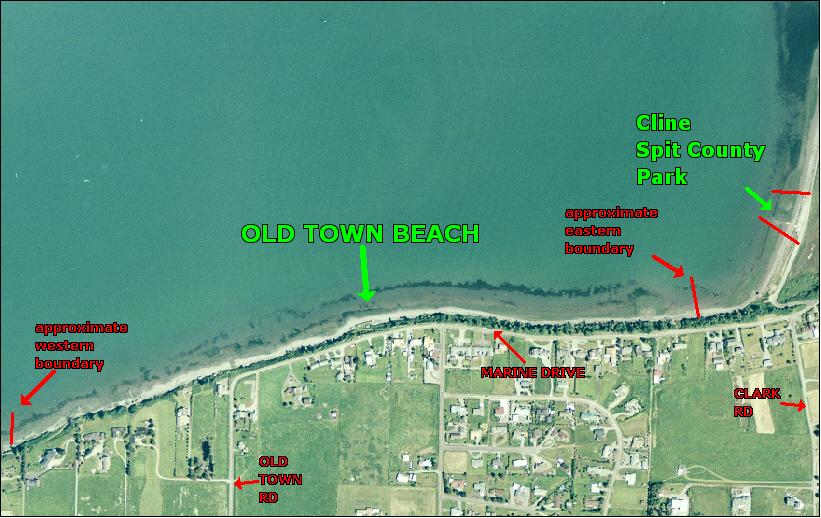
Old Town is boat access only. There is no upland access to this beach. It is about 0.6 miles long from boundary to boundary (see beach map photo). The eastern boundary of Old Town is about a half mile southwest of Cline Spit County Park. The western boundary is located about a half mile from the base of Dungeness Spit. Neither of the boundaries is well marked. The GPS coordinates for the midpoint of this beach are: 48.15ºN, 123.163ºW. Harvesters are advised to use these coordinates to stay near the midpoint of this beach to avoid trespassing.
Nearest boat ramps: Cline Spit ramp is about 0.4 nautical miles by boat to the midpoint of Old Town. Dungeness public boat ramp is located just off Marine Drive about a half mile north of the junction of Marine Drive and Sequim-Dungeness way. It is just over a mile by boat from Dungeness ramp to the midpoint of Old Town. There is a fee for launching at Dungeness ramp.
None. There are vault toilets and at Cline Spit and restrooms with indoor pluming at Dungeness ramp.