WDFW Beach Season Information
Clam, mussel, and oyster seasons OPEN for harvest January 1 through May 15, 2024 only.
Butter clams in Sequim Bay are often subject to biotoxin closures. Be sure to check the current Department of Health status the same day to you plan to harvest.
WDFW shellfish seasons indicate the specific times of year when harvesting is permitted. Before heading to the beach, please also check the Department of Health (DOH) information below which is related to health of the shellfish and may be updated daily. To harvest on this beach, it must be both during the WDFW approved season and approved by the DOH.
This beach has been enhanced with oysters.
This is a very good beach for butter clams and native littleneck clams. The best harvest area is south from the boat ramp to the dock and decent pockets of native littlenecks can be found north of the boat ramp in areas of mixed sand and gravel. Butter clams can be found in the lower intertidal zone in both areas. Sequim Bay is often subject to biotoxin closures. Always confirm current Department of Health status prior to harvesting clams at Sequim Bay State Park.
Oysters are available at Sequim Bay State Park in good numbers in the WDFW oyster enhancement plots (see beach photo for oyster plots). Most recent oyster plants have occurred south of the boat ramp.
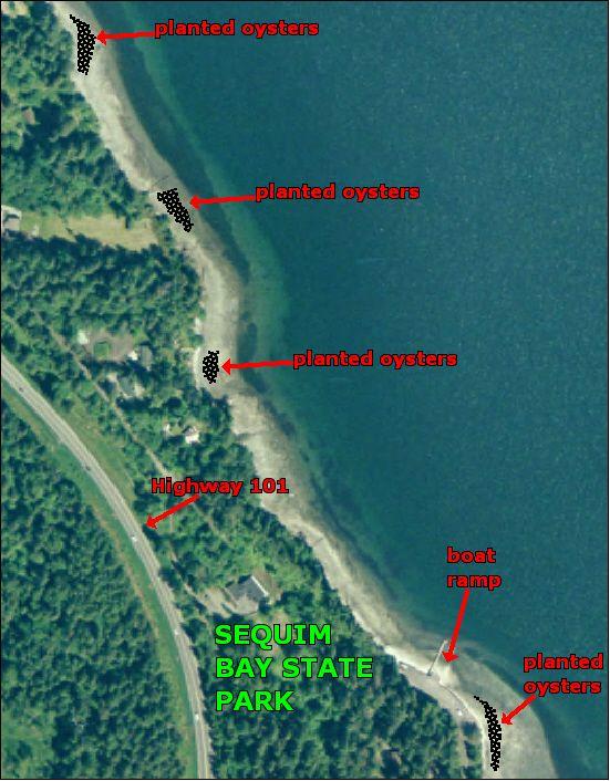
Sequim Bay State Park is located about four miles east of Sequim on Highway 101.
To reach the site from the west on Highway 101, travel east through Sequim and proceed for about four miles. Look for the signs that announce the entrance to the park. It is located on the northeast (left) side of the highway.
To reach the site from the east on Highway 101 from the Hood Canal Bridge, travel west on Highway 104 until Highway 104 merges with Highway 101, about one mile east of Discovery Bay. Continue west on Highway 101 for about another 15 miles. Look for the signs that announce the entrance to the Park. It is located on the northeast (right) side of the highway.
Sequim Bay State Park has camping, a boat ramp, dock, restrooms/showers, tennis courts, picnic area and a playground.
North of Sequim Bay State Park is the former site of the Jamestown S'Klallam village of Suxtcikwi'in, from which "Sequim", meaning "quiet waters" gets its name. Two natural overlapping sandbars protect the bay waters from the rough waves and currents of the Strait of Juan de Fuca. These same sandbars also protected the area from discovery by the first three expeditions that ventured into the Puget Sound. Due to the sandbars, low tide at Sequim Bay State Park is approximately 30 minutes later than the predicted time of low tide at the mouth of Sequim Bay.