WDFW Beach Season Information
Clam, mussel, and oyster seasons OPEN for harvest year-round.
WDFW shellfish seasons indicate the specific times of year when harvesting is permitted. Before heading to the beach, please also check the Department of Health (DOH) information below which is related to health of the shellfish and may be updated daily. To harvest on this beach, it must be both during the WDFW approved season and approved by the DOH.
![]() South Pitship Point
is accessible by boat only. There is no upland access to this beach.
South Pitship Point
is accessible by boat only. There is no upland access to this beach.
South Pitship Point is boat access only. There is no upland access to this beach. Please respect private property (see photo of beach). South Pitship is a productive clam beach. Available clam species on this beach include: native littleneck clams Manila clams, butter clams, cockles, and horse clams. Oysters are not expected to be common at this location.
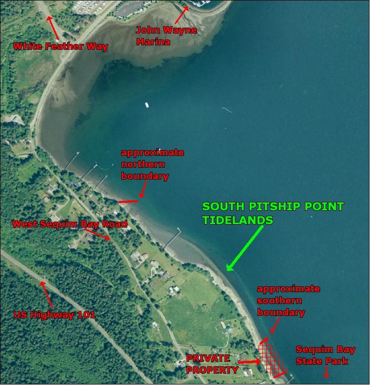
South Pitship Point is boat access only. There is no upland access to this beach. Please respect private property (see photo of beach). South Pitship Point is located on Sequim Bay, about 900 yards south of John Wayne Marina and approximately 60 yards north of Sequim Bay State Park Tidelands (see photo of beach). GPS coordinates for the middle of South Pitship Point are; 123.038º W, 48.054º N. Harvesters are advised to stay near these coordinates to avoid trespassing. The boundaries of this beach may not be marked.
Nearest boat ramps: John Wayne Marina (located east of Sequim one half mile north of Highway 101) is about 1,600 yards by boat to the middle of South Pitship Point. Sequim Bay State Park ramp (located southeast of Sequim on Highway 101) is about 1500 yard by boat from the middle of South Pitship Point. There is a fee for boat launching and parking at Sequim Bay State Park. There is a fee for boat launching at John Wayne Marina.
None. There are restrooms, a store, restaurant and moorage at John Wayne Marine. There are full park facilities at Sequim Bay State Park.