WDFW Beach Season Information
Clam, mussel, and oyster seasons OPEN for harvest April 1 through June 30, 2024.
Harvesting seasons apply to salt marshes and tidal beach area. Port Townsend Ship Canal (Portage Beach) shares a boundary with Indian Island County Park. This boundary is roughly marked by the jetty at the south end of the Port Townsend Ship Canal. Harvesting seasons may be different on these beaches. See the beach map photo below for the approximate boundary between Port Townsend Ship Canal tidelands and Indian Island County Park. The Port Townsend Ship Canal beach access is also known as Lions Club Park.
WDFW shellfish seasons indicate the specific times of year when harvesting is permitted. Before heading to the beach, please also check the Department of Health (DOH) information below which is related to health of the shellfish and may be updated daily. To harvest on this beach, it must be both during the WDFW approved season and approved by the DOH.
This beach supports populations of Manila, native littleneck, butter, Eastern softshell, horse, varnish clams, and cockles. There is a large variety of habitat types, including sand, gravel, broken shell, or a mix of those, as well as mud, eelgrass, and marsh side-channels. The north end of the beach has a lot of hardpan, but butter and horse clams can be found in the pockets of suitable substrate in between exposed hardpan. From the south end of the beach, north for about ½ mile, butter clams are found in the low to mid intertidal zone. The canal between Oak Bay and Port Townsend Bay has very strong currents. Combined with waves from passing boats, these currents move the substrate around considerably. As the substrate shifts, pockets of clams can disappear from time to time. If you are digging in one place and can’t find any clams, it may be beneficial to move to another location on the beach. Oysters are not common at this location.
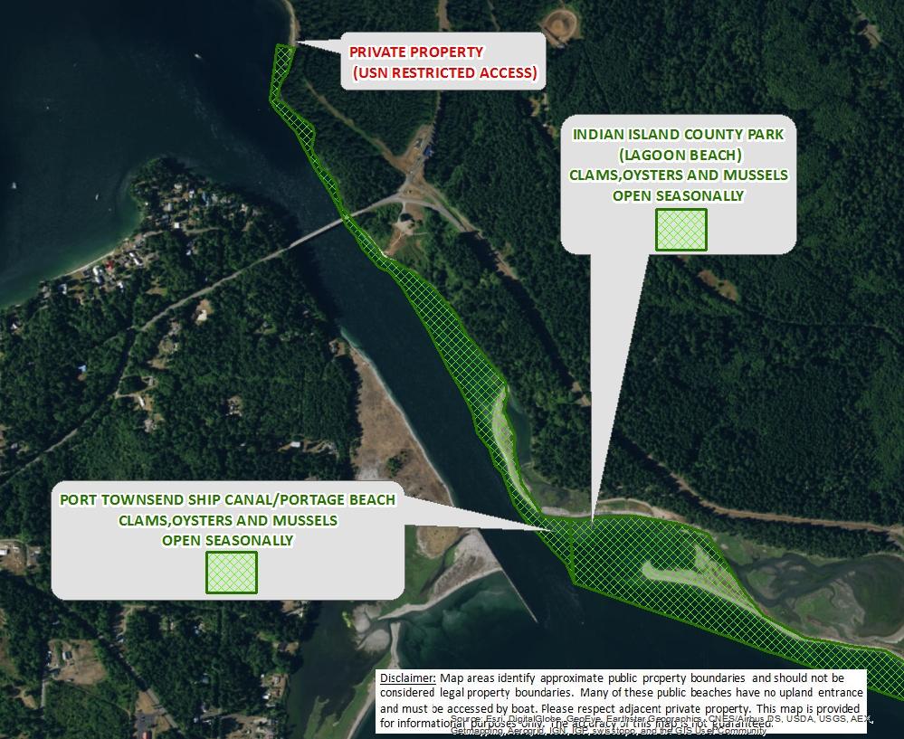
To reach the site from the west on Highway 104 take the Chimacum/Port Townsend/Quilcene exit (a left hand turn) and travel north on Center Road for about 10 miles to Chimacum. Go straight through the four-way stop and continue about 2 miles to Port Hadlock. Turn right onto Oak Bay Road and proceed for one mile to Flagler Road. There is a sign at this turn for Indian Island. Take a left and continue for about a mile until you cross the Indian Island Bridge. Immediately after crossing the bridge take the first right into the parking area for access to Port Townsend Ship Canal/Portage Canal tidelands. The north boundary of this beach is north of the bridge and is marked by the Indian Island Naval Reservation fence. There is absoulutely no trespassing allowed north of the fence.
To reach the site from the east on Highway 104 from the Hood Canal Bridge take the Port Townsend/Port Ludlow exit (a right hand turn) and travel north on Beaver Valley Road (Highway 19) for about 7 miles to Chimacum. Take a right at the four-way stop and continue about 2 miles to Port Hadlock. Turn right onto Oak Bay road and proceed for one mile to Flagler Road. There is a sign at this turn for Indian Island. Take a left and continue for about a mile until you cross the Indian Island Bridge. Immediately after crossing the bridge take the first right into the county park and parking area for access to Port Townsend Ship Canal/Portage Canal tidelands.
Port Townsend Ship Canal/Portage Canal tidelands can also be accessed from South Indian Island County Park. This access is located about a half mile south of the bridge on the right side of the road. The access road is marked by a Jefferson County Parks sign. There is a parking lot at the end of the road. The boundary between South Indian Island County Park and Port Townsend Ship Canal tidelands is just north of the landward end of the jetty at the south end of the Ship Canal. See beach map photo for the approximate south boundary of Port Townsend Ship Canal. Because the Ship Canal tidelands may be open for clam harvest when South Indian Island County Park is closed, it is important to know where the approximate boundary is.
There is a pit toilet, picnic tables, and a covered cooking area near the parking area by the bridge. A trail system from the parking area leads to Indian Island County Park.
In 1915, Indian Island was isolated by dredging of Chimacum Portage to make the Port Townsend Ship Canal/Portage Canal. In 1952 the Indian Island Portage Bridge was built to replace the ferry to mainland. This area was historically known as the Craven Peninsula before Indian Island was separated from the mainland.