WDFW Beach Season Information
Clam and mussel seasons CLOSED until further notice due to decline in clam abundance.
Oyster season OPEN for harvest January 1 through June 30, 2024.
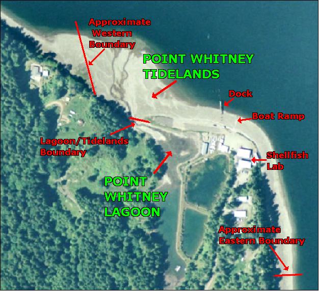
Clam, mussel, and oyster seasons are the same for Point Whitney Tidelands and Point Whitney Lagoon.
Other good clamming beaches nearby include Quilcene Bay WDFW Tidelands (open year-round) and Duckabush Tidelands (open November through April). You can search for many more using the Find a Beach tool.
Clam harvest CLOSED in 2023 to encourage recovery of clam populations.
WDFW shellfish seasons indicate the specific times of year when harvesting is permitted. Before heading to the beach, please also check the Department of Health (DOH) information below which is related to health of the shellfish and may be updated daily. To harvest on this beach, it must be both during the WDFW approved season and approved by the DOH.
There are oysters in the lagoon and on the outer tidelands. The average size for oysters is small and harvesters are reminded that there is a 2 ½ inch minimum size. The highest oyster abundance is around the point at at the south end of the outer tidelands.
From the south, follow Highway 101 though the town of Brinnon and proceed north for about three miles. Turn right at the Cove RV Park and Grocery onto Bee Mill Road. Continue for two miles to the Point Whitney Shellfish Lab. There is ample parking at the end of the road west of the Lab.
From the north, follow Highway 101 south through Quilcene for about 8 miles and turn left at the Cove RV Park and Grocery onto Bee Mill Road. Continue for two miles to the Point Whitney Shellfish Lab. There is ample parking at the end of the road west of the Lab.
A Discover Pass or Vehicle Access Pass is required to park at this site. The former WDFW Point Whitney facility on site is now occupied by a private shellfish aquaculture operation. The facility requires shellfish trucks to maintain access to certain areas along the road. Please respect signage on-site regarding parking along the road and avoid interfering with the facility's operations.
There are public restrooms on site and an information kiosk near the boat ramp. The boat ramp is often covered with gravel and four-wheel drive vehicles are recommended for launching boats here (the ramp is cleared periodically ahead of major fisheries openers). There is a picnic table and fire/cooking ring at the north end of the parking lot.